Note - This page was last updated in May 2023, with revisions to the hazard land levels and other statistics and data relating to water levels, to reflect the high water in 2022. Are you thinking of shoreline work or construction on your property? Then it is important to consider water levels. Find out more in the following sections:
Water Levels and Hazard Lands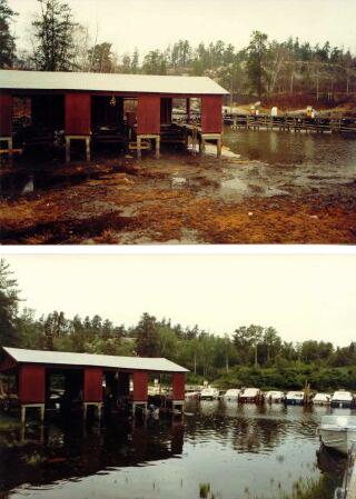 Water levels typically move up and down seasonally and can also be quite different from one year to
another. In particular, it is important to be aware that water levels can vary considerably over
relatively short time periods in response to heavy rainfall or dry periods. On Lake of the Woods,
while the "normal" annual variation in water level is only 0.6-0.9 m (2-3 ft) or less, levels
through the years have varied over a 2.5 m (8.3 ft) range. On the Winnipeg River, water levels at
some locations may vary up to 1.5 m (5 ft) fairly often and can rise 3.5 m (11.5 ft) or more when
the dam at Kenora is fully opened. When building or developing, it is important to allow for water
level fluctuations, recognizing that while the water level may normally be in a certain range, it
can and will periodically rise much higher. Development in areas that are subject to periodic
flooding will ultimately result in personal anxiety and property damage that could have easily been
avoided.
Water levels typically move up and down seasonally and can also be quite different from one year to
another. In particular, it is important to be aware that water levels can vary considerably over
relatively short time periods in response to heavy rainfall or dry periods. On Lake of the Woods,
while the "normal" annual variation in water level is only 0.6-0.9 m (2-3 ft) or less, levels
through the years have varied over a 2.5 m (8.3 ft) range. On the Winnipeg River, water levels at
some locations may vary up to 1.5 m (5 ft) fairly often and can rise 3.5 m (11.5 ft) or more when
the dam at Kenora is fully opened. When building or developing, it is important to allow for water
level fluctuations, recognizing that while the water level may normally be in a certain range, it
can and will periodically rise much higher. Development in areas that are subject to periodic
flooding will ultimately result in personal anxiety and property damage that could have easily been
avoided.
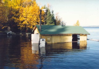
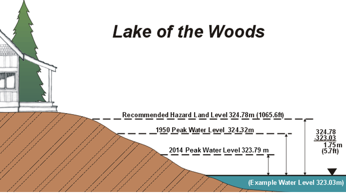
For most of the water bodies under its mandate, the LWCB recommends a "hazard land" level. This is a level, above the normal water level, to which the lake or river can be expected to rise periodically, thereby inundating everything in the "hazard land zone" below this level. Buildings with living space and other valuable structures should only be built above the hazard land level. Only docks and boathouses should be built below this level, with the understanding that they are in an area at risk and will likely be flooded from time to time. The hazard land level is generally based on historic flood levels, plus an allowance for wind and wave action. The hazard land designation is not a guarantee that water levels will not rise even higher under extreme weather conditions; rather it indicates an area that is sufficiently likely to be flooded periodically that precautions should be taken.
Recommended Hazard Land LevelsThe hazard land levels recommended by the Board, below which there should not be any development apart from docks and boathouses (which are acknowledged to be at risk) are:
The two sets of values in the above table are necessary due to differences in the way levels are measured. All land and water levels are commonly referenced to "sea level", the nominal level of the oceans. Reported levels are "height above sea level". Unfortunately, the datum for these levels has changed over time, due to different surveying techniques, different starting points, and even due to movement of the land mass. Water levels are still reported in terms of reference points established in the early 1900's, when legislation and treaties defining water level ranges were put in place. In contrast, land levels are typically reported in terms of revised reference points. Thus it is important to confirm the datum. For further explanation, please call the Board office at 1-800-661-5922.
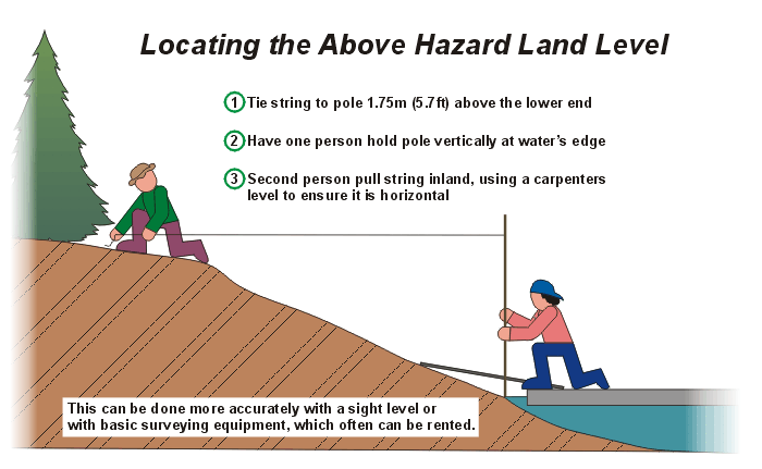
How to Determine Levels on your ShorelineThe location of the hazard land level or contour on your property can be accurately determined by a licensed or registered land surveyor, using standard survey techniques. In Ontario this would be a person with the "OLS" (Ontario Land Surveyor) designation. The surveyor would use the "Land Surveys" hazard land level as defined in the previous section.In many areas it is also possible to locate the hazard land level or contour yourself in an approximate fashion. From this web site (www.lwcb.ca), or by calling the Board's office, you can find out the actual water level in your area on a particular day. Subtract this actual water level from the "Water Levels" hazard land level (see previous section) to find the vertical distance between these two levels. Now picture a horizontal line this vertical distance above the water level and running inland. As shown in the first sketch below, where this line meets the rising slope of your land is the top of the hazard land zone. By this same means, you can determine (approximately) any other level on your property. For example, by using the peak level recorded in 1950 (a record flood year) in place of the hazard land level in the above procedure, you could determine the height the water rose to in 1950 on your property (before consideration of wind and wave action). This is also demonstrated in the first sketch below. Similarly, the design height for docks or their shore connections can be established. The second sketch below shows one simple means of finding these levels on your property.
This method can be reasonably accurate on lakes as long as you choose a calm day that has been preceded by one or two calm days, so that the water level is not unduly affected by wind action. The level of Lake of the Woods, for example, can vary by 0.6 m (2 ft) or more from one side to the other due simply to sustained wind effects. This method can also be effective on rivers, provided that your location is close to an existing water level gauge. This is essential since the water level of a river declines as you move downstream, such that water levels are different all along the length of the river to varying degrees. For the Kenora to Minaki portion of the Winnipeg River, you can also get a rough idea of the water level at your location by first finding out what the outflow from Lake of the Woods is (from this web site or by calling the Board office) and then referring to the graph of the river profile found in the "Docks - Winnipeg River (Ontario)" section on this web site.
Another Consideration; Erosion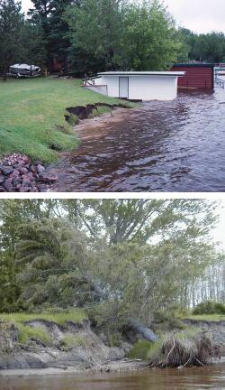 In some areas, in addition to simple flooding, shoreline erosion must also be considered. This can
be a much more complex issue and often needs to be dealt with on a site by site basis. On Lake of
the Woods, erosion is usually not a factor for much of the Canadian shoreline due to the
predominance of the Canadian Shield, but can be significant on the southwest shore (Buffalo Bay) and
on the southeast shore south of Morson. Erosion can be significant on much of the United States
shoreline of Lake of the Woods. Erosion is also a factor along portions of the Winnipeg and English
Rivers, and certainly on Lac Seul.
In some areas, in addition to simple flooding, shoreline erosion must also be considered. This can
be a much more complex issue and often needs to be dealt with on a site by site basis. On Lake of
the Woods, erosion is usually not a factor for much of the Canadian shoreline due to the
predominance of the Canadian Shield, but can be significant on the southwest shore (Buffalo Bay) and
on the southeast shore south of Morson. Erosion can be significant on much of the United States
shoreline of Lake of the Woods. Erosion is also a factor along portions of the Winnipeg and English
Rivers, and certainly on Lac Seul.
On all shorelands except rock, the Board strongly recommends that the natural vegetation in the hazard land zone not be disturbed. Further, this vegetation should be replaced and/or supplemented when damaged. Clearing of natural vegetation, and sowing grass, will result in erosion even in areas of low susceptibility. In addition, removal of the natural vegetation both on-shore and in the near-shore area is often harmful to the environment and the living species it supports. In principle, in the Board's view, land that is subject to active erosion should not be developed regardless of the elevation. Erosion is a dynamic, long-term process that results in the loss of land, faster in some years than others. This loss will cause distress to the landowner even if buildings or other structures are not immediately threatened. Placement of fill on low-lying shorelands is also not recommended as, without proper protection, it is likely to be much more erodible than the natural shoreline with native vegetation. Nevertheless, development might proceed under certain site specific conditions. In Canada, on lands that are deemed to be erodible, the Board works with provincial agencies and local municipalities to determine if development is viable and, if so, under what conditions. A site inspection and erosion potential analysis is performed first, conducted by an appropriately qualified and licenced professional. The analysis should include recommendations on what erosion protection measures would be effective, and what impact they might have on adjoining properties. Then, subject to review of the results, development might be acceptable subject to certain requirements being met. Costs of erosion protection works can be quite high, both for the analysis and design phase, and then for construction. On-going maintenance is often also required. Further, if not properly designed (and in some areas even with the best of designs), the protection works can prove to be detrimental to adjoining properties. Altering the sediment transport processes in one area of the water body may lead to increased erosion elsewhere. Due to the costs involved and the expertise required, development of private residential and recreational properties is likely only viable in areas of zero to low erosion potential / erosion rate. For such properties, adequate erosion control may be effected at reasonable cost by planting and/or maintaining erosion-resistant vegetation along the shorefront, or by placing simple erosion-resistant materials such as stone of adequate size on a stable base. In addition to, or as an alternative to protection works, development may be restricted to beyond a horizontal setback inland from the hazard land contour, thereby allowing for some loss of shoreline over the design life of the structure. The setback would be the estimated annual erosion rate times the design life of the structure. For commercial development, on the assumption that more money would likely be available for both the initial development and for on-going maintenance, development of more severely eroding shorefront may be viable. Extensive fill placement, coupled with engineered protection works, could be required and would have to be assessed very carefully. The services of a qualified shoreline management engineer would be required to properly design the protective measures. Requirements for on-going monitoring and maintenance may be appropriate.
Docks The Board recommends the use of floating docks wherever possible, and especially along the Winnipeg
River north of Kenora where changes in water level can be quite significant and rapid. With a
floating dock, the dock surface will be a convenient height above the water surface at all times,
regardless of water level fluctuations.
The Board recommends the use of floating docks wherever possible, and especially along the Winnipeg
River north of Kenora where changes in water level can be quite significant and rapid. With a
floating dock, the dock surface will be a convenient height above the water surface at all times,
regardless of water level fluctuations.
When constructing the fixed shore portion and moorings for a floating dock, or when constructing a fixed (pole or crib) dock, it is important to consider the range of water levels likely at your site. The sections below will provide some guidance in this regard for several locations, as will the current and historic graphs of water levels found elsewhere on this web site. You can establish a reference level on your property by checking current water levels on this web site or by calling the Board's office; see the previous section on "How to Determine Levels on your Shoreline". Remember that, of necessity, docks (and boathouses) must be constructed in the hazard land zone. They are thus subject to periodic damage from high and low water levels, from wind and wave action, and from winter ice. Construct your dock to minimize these damages as best as possible, but accept that periodic maintenance and repair is the price of enjoying the water's edge. Also, if your property is particularly at risk from changing water levels, or you need to make adjustments to your dock or take other action to cope with more extreme water levels, make sure you check this web site or the Board's recorded messages frequently to find out what is happening with water levels. It should be noted that Transport Canada regulates the construction of docks on navigable waters in Canada. If your dock meets the criteria set out in Transport Canada�s Minor Works Order (Works on navigable waters in Canada), then you are free to build. If your dock does not meet the Minor Works Order, and your dock is being installed on a body of water found on the Schedule to the Act, then you are required to submit an application for approval to Transport Canada. If your dock is being installed on a navigable water body that is not found on the Schedule, then you can either submit an application for approval, or follow the public resolution process.
Applications can be submitted through the External Submission Site.
For more information, please contact the Navigation Protection Program at NPPONT-PPNONT@tc.gc.ca, or
visit Transport Canada�s website Navigation Protection Program (canada.ca).
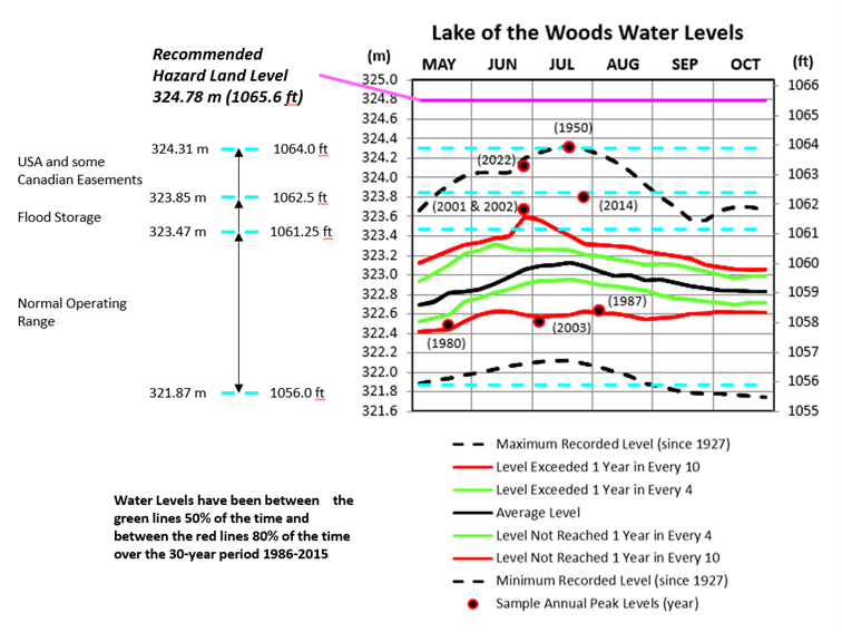
Lake of the WoodsAs mentioned previously, the Board recommends a floating dock wherever possible. For the fixed shore portion of a floating dock, a top level of 323.7 m (1062 ft) will provide a surface that would have been overtopped only 3 times since 2000. Lower levels than this may be more convenient (depending on your shoreline) and will result in a less steep ramp to the floating portion, but will be subject to overtopping and getting wet from waves more often.For a fixed dock, a deck elevation of 323.55 m (1061.5 ft) would be reasonably safe from overtopping and wave action but wouldn't be too high above the water surface for convenient mooring during the summer months in most years. Note, however, that the most recent high water year of 2022 reached 324.12 m (1063.4 ft), which exceeded the deck elevation by 57 centimeters (22.4 inches). It is important to note that waves and wind setup would have resulted in higher local levels at times. The graph below shows the average level during the boating season over the 30-year period 1986-2015, and the frequency of overtopping certain levels.
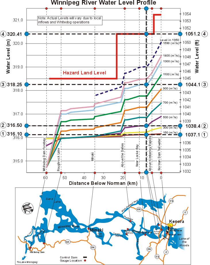
Winnipeg River (Ontario)Water levels on the Winnipeg River from Kenora north to Minaki and Whitedog are affected primarily by the amount of outflow from Lake of the Woods. They are also affected by local runoff along the river (such as from the Black Sturgeon system) and by operations at the Whitedog hydroelectric generating station. Levels vary significantly along the river, in the order of 3.5 m (11.5 ft) or more just north of Kenora, and decreasing as you move further north (further downstream) to a level range in the order of 1.2 m (3.9 ft) or more at Minaki. In addition, changes in level may occur fairly rapidly. Consequently, the Board strongly recommends the use of floating docks along the river. Careful planning is also needed to ensure that your dock, its moorings and the shore approach to it can accommodate the range of levels to be expected at your site.The following figure can be used to get an idea of the water level range at your property. You can also use it to get a rough idea of the water level at your property on any given day, so that you can determine how much higher and how much lower you should plan for. The upper portion of the figure shows the approximate water surface profile along the river for a number of different outflows from Lake of the Woods. The river profile becomes steeper as the outflow from the lake is increased. The brown (bottom), least steep line is for a Lake of the Woods outflow of 150 m³/s, while the pink, much steeper line near the top is for an outflow of 1400 m³/s. The dashed blue line, that is higher still, shows the estimated river profile (based on very limited data) in 1950 at a Lake of the Woods outflow of 1590 m³/s, the highest recorded to date. The top heavy red line shows the recommended hazard land level, as set by the Winnipeg River Settlement Board in 1939. The current outflow from the lake can be found elsewhere on this web site, or by calling the Board's office. The following example will help to explain how to use the figure:
Of course, while the above is what happened on average over a specific 30-year period, high outflows can occur more frequently. For example, in 1950, outflows remained above 1400 m³/s for more than 15 weeks, and in 2014, outflows remained above 1300 m³/s for 8 weeks. Most recently, in 2022, outflows remained above 1400 m³/s for 10 weeks. The 30-year average outflow from Lake of the Woods is 415 m³/s.
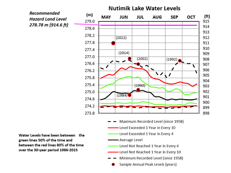
Nutimik Lake, Winnipeg River (Manitoba)Water levels along the Winnipeg River in Manitoba are affected by outflows from both Lake of the Woods and Lac Seul. They are also affected by tributary inflows to the English River (downstream of Lac Seul) and to the Winnipeg River (downstream of Lake of the Woods in both Ontario and Manitoba). Further, levels in the lakes along the river are affected by channel constrictions at the lake outlets. Some areas are also affected by operations at Manitoba Hydro hydroelectric dams and powerhouses.The Board strongly recommends floating docks for the Winnipeg River in Manitoba, as it does for the river in Ontario. On Nutimik Lake, for the fixed shore portion of a floating dock, a top level of 276.5 m (907.2 ft) will provide a surface that was overtopped 7 years since 2000. A lower fixed portion than this may be more convenient in many years, depending on the steepness of your shoreline, but would be overtopped more often. For a fixed dock, a lower deck level would be required to provide convenient boat access in most years. A deck elevation of 276.0 m (905.5 ft) was overtopped 10 years since 2000 (but by as much as 1.7 m [5.71 ft]), and yet would be 1.8 m (5.9 ft) above the water surface during low water periods. The graph below shows the likely average water level during the boating season over the 30-year period 1986-2015, and the frequency of overtopping certain levels.
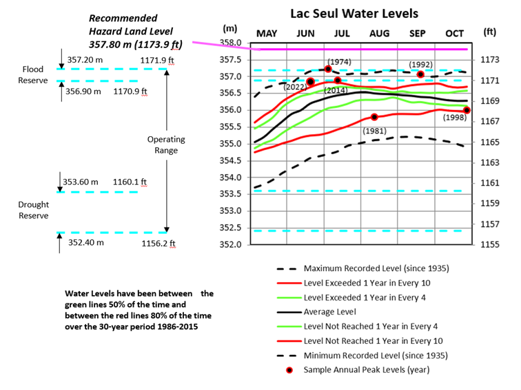
Lac Seul (main lake)Design and construction of docks on Lac Seul pose a significant challenge because of the large range of lake levels experienced. As can be seen from the figure below, the absolute historical range from May through October is 3.5 m (11.4 ft).Floating docks, or a system that incorporates floating components, are highly recommended in order to accommodate the large fluctuation in water levels. For the fixed shore portion of the dock system, a top level of 357.2 m (1071.9 ft), the top of the defined operating range, is recommended. Although the mean lake level has never exceeded this elevation, it has been very close and wave action would have overtopped a dock at this level in the highest years. The greater the exposure to winds and open stretches of water, the more waves would be likely to overtop this level. Note, however, that even the median level (the lake is lower still one-half of the time) at the beginning of the walleye fishing season in late May is only 355.2 m (1165.4 ft), or 2 m (6.6 ft) below the recommended level. This shows the importance of having floating components so that a section of dock is at a reasonable height to give boat access at the lower lake levels. If a fixed dock is considered the only option due to wind/wave exposure or other concerns, the range of levels must be accommodated by different means. Several fixed docks of different elevations could be constructed, or one fixed dock with several sections at different elevations. One dock or dock section should be at the level recommended above, with lower docks or dock sections for use at lower lake levels. These lower docks would, of course, be inundated more frequently and would be more susceptible to damage from wave and ice action. Another option might be to form a breakwater with part of the fixed dock and use floating finger sections for direct access to boats at lower water levels. In either case, ladders may be required when water levels are lower. The graph below shows the average level during the boating season over the 30-year period 1986-2015 and the frequency of overtopping certain levels.
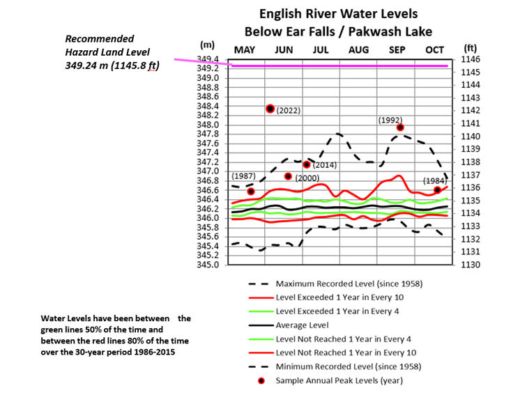
English River below Ear Falls / Pakwash LakeWater levels on Pakwash Lake and on the English River from Ear Falls to the "chute" at the Highway 804 bridge are affected by flows in the river and by operations at Ontario Power Generation's Manitou Falls generating station. The flows in the river are a function not only of the outflow from Lac Seul at Ear Falls but also of flows from local tributaries, including the Chukuni and Troutlake Rivers from the north and the Cedar River from the south. Water levels in this area can change quite quickly due to changes in the river flow and/or changes in the Manitou Falls forebay level.The recommended top of deck level for the fixed shore portion of a floating dock on Pakwash Lake and the Ear Falls - Manitou Falls portion of the English River is 347.2 m (1139.1 ft). This level has been exceeded 3 times since 2000. The highest level recorded in the area since 1958, when improvements were made in the constricted channel downstream of Camping Lake (the "chute"), was 348.24 m (1142.5 ft) just below Ear Falls in the spring of 2022. A dock built to the recommended level would be inundated by 1.04 m (3.4 ft) at the level reached in 2022. For a fixed dock, a deck set lower, at elevation 346.8 m (1137.8 ft), might be a reasonable compromise between overtopping and convenient use at lower water levels. This level was exceeded in a total of 8 years since 2000, and may have been overtopped by wave action in additional years. The graph below shows the average level during the boating season over the 30-year period 1986-2015 and the frequency of overtopping certain levels.
Anyone who has questions, would like further explanation of the material found here or would
like help in establishing a reference elevation at their property should not hesitate to call
the Board's Secretariat at References"The Dock Primer" and "The Shore Primer" (both PDF files), produced by Cottage Life in
association with
Fisheries and Oceans Canada, are useful guides for planning and building docks and for
working
in the shore zone. files), produced by Cottage Life in
association with
Fisheries and Oceans Canada, are useful guides for planning and building docks and for
working
in the shore zone.
|
|||||||||||||||||||||||||||||||||||||||||||||||||||||||||||||||||||||||||||||||||||||||||||||||||||||||||||||||||||||||||||


 In past years the LWCB has worked with provincial and municipal planning authorities to have
appropriate hazard land levels implemented in zoning and approval processes. For example, the
Board's recommended
level for Lake of the Woods is used to define hazard lands (with appropriate building
restrictions) in the City of Kenora official plan and zoning bylaws. In unorganized portions of
Ontario around Lake of the Woods, "flowage easements" to the Board's recommended level are
required by the Ontario Ministry of Municipal Affairs and Housing before development and
severance approvals are granted. In the United States, a flowage easement exists on all Lake of
the Woods shoreline, although this is only up to the flood level that has actually occurred
historically and does not include the wind and wave allowance that is part of the Board's
current recommended level.
In past years the LWCB has worked with provincial and municipal planning authorities to have
appropriate hazard land levels implemented in zoning and approval processes. For example, the
Board's recommended
level for Lake of the Woods is used to define hazard lands (with appropriate building
restrictions) in the City of Kenora official plan and zoning bylaws. In unorganized portions of
Ontario around Lake of the Woods, "flowage easements" to the Board's recommended level are
required by the Ontario Ministry of Municipal Affairs and Housing before development and
severance approvals are granted. In the United States, a flowage easement exists on all Lake of
the Woods shoreline, although this is only up to the flood level that has actually occurred
historically and does not include the wind and wave allowance that is part of the Board's
current recommended level.
 Return to LWCB Main Page